


Time for Reflection: Upper Currumbin Valley in the Gold Coast Hinterland
By Denis Bright
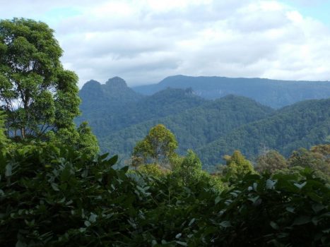
Less than forty kilometres upstream from the Currumbin Estuary on the Southern Gold Coast, visitors can be treated to the delights of the Mount Cougal National Park. Welcome to a world of tall forests, waterfalls and cascades. Torrents of cold clear water sweep down from the coastal ranges near the border with NSW. All this challenges the conventional tourist mosaic of the Gold Coast.
Compared with hikes into the wider Springbrook National Park, this Mount Cougal Section is quite compact. The twin peaks of Mount Cougal straddle the Upper Currumbin Creek on both sides of the catchment.
Elevations adjacent to the twin peaks approach 700 metres.
No forest location is without its hazards to the unwary. Rock-sliding down the cascades near the car park entrance should always be avoided.
Casual visitors are still able to enjoy the ambiance of this location and can walk along the creek from the end of the paved walking track to the Mount Cougal Cascades. This is about three kilometres beyond the paved walking track to the partly restored heritage saw-mill site.
The forest and creek are best after rain which sweeps away accumulated flood debris which might contain some hazards of the forest.
This also makes walking through the shallow creek channel so much easier as the water is crystal clear.
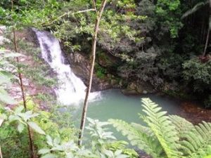
The Mount Cougal Cascades (from Southern Gold Coast Online 2016)
There are numerous reviews of this locality online from bush-walking groups.
Sites along the creek can be placed in a better context preparatory reading from Rocks and Landscapes of the Gold Coast Hinterland.
This outstanding monograph was prepared by a team from the Queensland Division of the Geological Society of Australia under the direction of Warwick Willmott. This publication invites readers to take an interest in the natural history of the Gold Coast hinterland in the genre of specialist writers who want to share their knowledge with a wide public audience.
One of the many maps and sketches has been added to share some of this technical enthusiasm for natural history.
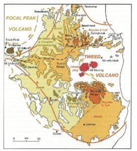
Lava flows near the Border Ranges: (Willmott 2010)
Lavas from the Tweed Volcano were extruded 23-24 million years ago to conceal the older rock surfaces in the Gold Coast Hinterland.
The Currumbin Valley has since cut into these lava flows to reveal cliffs of rhyolite and tuff which make the hike to the twin peaks very challenging.
Along the creek itself the minor and major cascades represent other stages of the dark lava flows.
Invite an indigenous elder and a field geologist on your outing if your party needs more precise identification of the rock formations and their significance.
The Yugambeh people lived in Mt Cougal and Springbrook’s valleys for at least 6,000 years. It was a meeting place for indigenous people from as far afield as Maryborough. Tribal feasts were held at Bora rings and middens.
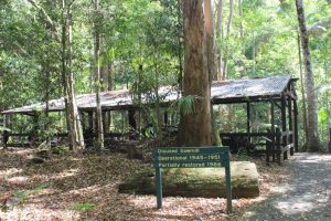
The partly restored remains of a saw-mill near the paved walking track from the car-park are a reminder of the human impact from logging operations in the vicinity of Currumbin Creek. Bush tracks were once traversed by heavy vehicles.
When development was less sustainable?
With contemporary commitment to improved sustainability in Australian lifestyles, it is important to weigh up the environmental impact of an outing to the bush versus an outing to a theme park or attendance at a movie matinee with treats of take-away foods.
Earlier generations had fewer choices about their consumer options. My father Colin Bright (deceased in 1989) did some casual work on banana plantations in the Currumbin Valley during the jobless era of the 1930s. He also joined the Currumbin Surf Life-saving Club.
The Depression years were not a time for vast choices. At a distance of forty kilometres on bush roads, a day out to the Upper Currumbin Valley would have been quite an adventure.
So if tomorrow’s choice of activities is a visit to the Mount Cougal National Park, value your right of passage on the sealed roads back to your natural history.
 Denis Bright (pictured) is a registered teacher and a member of the Media, Entertainment and Arts Alliance (MEAA). Denis has recent postgraduate qualifications in journalism, public policy and international relations. He is interested in promoting discussion about progressive pragmatic public policies compatible with contemporary globalization.
21 comments
Login here Register here-
Jaquix -
Matters Not -
Rhonda -
townsvilleblog -
Leila Smith -
Denis Bright in Brisbane -
Denis Bright in Brisbane -
Kaye Lee -
Matters Not -
Jacki -
LOVO -
John Brame -
Pat -
Jaquix -
Maria -
paul -
Royce Arriso -
Abdul -
corvus boreus -
Jasper -
Denis Bright in Brisbane
Return to home pageThank you Dennis Bright for highlighting a gorgeous part of the world. Even today a visit to the Currumbin Valley is a bit of an adventure, certainly a complete change of scene for city slickers, even if they only drive to the end of the Currumbin Valley Road, it is just SO beautiful and serene, and of course very accessible. Everyone knows the Gold Coast as the “glitter strip” but the Hinterland is right there too, the “Green behind the Gold” and not yet exploited by tourism operators.
Denis, I spent many a school holiday at Currumbin. Knew many members of the Vikings including some of their ‘legends’ including many Olympians. I was a member at North Kirra, further south. (And have the skin cancers to prove it.)
We used to go up the valley to swim in the rock pools but haven’t been back for decades. Indeed it’s a beautiful part of the world.
Thanks Denis. Have made a reminder note to check out this beautiful area during our visits to the beach this holiday season 🙂
The great South-East corner, gets 90% of the Queensland government funding, at the expense of the rest of Queensland. Townsville, the unofficial capital of a proposed State of North Queensland, doesn’t even have a regular bus service, let alone light rail. We see the traffic congestion nightly in Brisbane, and have the same in Townsville, only problem being the absence of public transport up here. All of regional Queensland is ignored by the Queensland government no matter which political stripe it has. We have equally as good sites in NQ but difficult to get to because all we get is dirt roads.
Great article Denis & a timely reminder of the natural beauty that we are so priveleged to visit close by
It was my good fortune to organise about thirty environmental studies to the Upper Currumbin Valley over quite a number of years.
I would not have ventured past the saw-mill until I was shown the way by one of the staff members at the adjacent Camp Eden Health Resort.
I like being able to mention my father, Colin Bright in my writing. Colin had no sight in his left eye from a childhood accident. It did not appear to be damaged in any way to a casual observer. There were no special job assignments for him.
I never chatted with Colin in any detail about the Currumbin SLSC. I know that he attended a reunion around 1960 with a neighbourhood friend in Frank Fullelove who may have been involved with the Club. He was also from Blackall Street, East Ipswich.
More significant in his conversation were the working and living conditions for casual workers on banana plantations in the Currumbin Valley.
It seems that job hire schemes and cash wages are not a modern invention.
Thanks for your comments, Matters Not. I hope you can visit the Mount Cougal Cascades and Rock Pool the day after a heavy storm when the water will be cold and clear from the recent turbulence.
Thanks Leila. Mt Cougal National Park is so inviting. I must admit that I am a more sedentary visitor and would not make it up East or West Peak.
I like getting older. We explore beyond the beaches and bright lights and frenetic pace that we enjoyed in our youth. My childhood is chronicled by photos at the Currumbin bird sanctuary. Next time I am up that way I will go take a look further afield. There are so many treasures to explore – thank you for giving me another one.
Denis given your father’s ‘timeframe’ I suspect he knew Robert Neumann whose family had the ‘sand mine’ at the mouth of Currumbin Creek and who was also a strong supporter of The Vikings (Currumbin SLSC). In later years, he moved into the gravel and earthmoving business in a big way, then became Mayor of the Gold Coast. They have named a ‘park’ after him on the Currumbin Valley road.
As an aside, your phrase ‘right of passage’ initially caused me to raise an eyebrow – rarely used correctly. Had to read the sentence again in context of the whole piece before I really understood the point that was very well made.
KL, wait till you reach 70 when the body really begins to deteriorate. But enjoy it when you’re able.
The article provides an interesting background to a visit to the Currumbin Valley- worth a trip on a day when it is too hot at the beach over summer.
Denis, with my tounge firmly in my cheek, I say ….”What is it with you banana benders and theme parks”. 😯
P.S….and just when I was wondering where to take the kids this chrissy…mm… 😉
I was born in Brisvegas but have never been to Currumbin Valley. Looks beautiful. Nature rules.
You’ve inspired me to explore this beautiful part of the world – it’s has been years since I’ve been there but I’m now planning my return visit!
Dont forget there are other Hinterland beauty spots like also Natural Bridge (Arch) , Springbrook and Purlingbrook not so far away either – though different roads to get to them. Or even the new (now double capacity) Hinze Dam which is only 10 minutes from the M1.
Definitely inspired me to visit this place. It is a privilege to have so much natural beauty close to Brisbane. Thanks for your article Denis.
Excellent reminder to visit a wonderful spot on the Gold Coast Denis! A place I have been to several times after your initial recommendation years ago! I have also shared this with my friends who are now regular visitors on a hot day.
Walking along the creek up stream is a real treat. The water is absolutely clear and quite cold after heavy rains – a great break from the beach on a hot summers day. A good few degrees cooler under the canopy of the forest. And, as another reader mentioned – just the drive out there is great. You will pass the “Eco Village” on the way – a reminder to passers by of the importance of living sustainably.
Thanks for sharing.
Anybody enlighten me as to the identity of that distinctive ‘bull-nosed verandah’ mountain frowning into NSW from the Border Ranges? Was visible from almost any part of far NE NSW when I once drove through, forty years ago.
Great article Denis! I love this part of SEQ.
Royce Arriso,
Most likely answer would be Wollumbin / Mount Warning, which is the most prominently visible mountain from far-northern NSW coast roads, and has something of a blunt bull-nosed shape..
It is the remnants of the plug in the centre of a volcanic caldera, of which the Border Ranges forms the northern rim.
Here is a stock picture taken from the north-east; http://helicoptertours.com.au/wp-content/uploads/2012/07/Mt-Warning-Heli.jpg.
Mt Cougal is a beautiful part of the Gold Coast.
Let’s visit the Gold Coast
To see the brick veneer plains
Those one stop shopping centres
With scorching asphalt frames.
But up the road at Mt Cougal
Explore a timeless forest land
Spirit of Yugambeh flourish
The future is in our hands.
Don’t let the development industry
Turn Mount Cougal into cash
Or farewell kangaroo character
Just 25 million saps.
Q Government through QTopo provide free access to online topographic maps which can be reproduced without copyright problems
at the scale of your choice: http://qtopo.dnrm.qld.gov.au/Mobile/
I expect that other states and territories would have similar resources.
This is an excellent resource for the holiday period when visiting both the places of your choice or simply looking back on previous trips.
Fostering an enthusiastic sense of place is a vital challenge.
This certainly beats the old paper maps as snipping tools can create the map of your choice and the precise scale is shown with each enlargement or reduction.